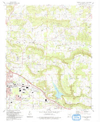
1993 Map of Russellville East
USGS Topo · Published 1993About this map
The growth of Russellville and Pottsville dominates this Pope County landscape during the early 1990s, with residential expansion stretching toward the base of Carrion Crow Mountain. The eastern edge of Russellville features critical municipal infrastructure, including the County Fairground, the Armory, and the Municipal Airport. In contrast to the industrial and urban development of the city, the outlying areas maintain a high density of rural religious and community landmarks, such as Victory Tabernacle and Liberty Grove Ch.
Find a feature on this map
54 named features on this map. Tap any name to fly to it.
Don’t see what you’re looking for? This feature index may not catch every label — zoom into the map to look around manually.
Map Details
Editions of this 1993 Russellville East Map
This is the sole edition of this map. No revisions or reprints were ever made.
Other maps of this area

1888 · Dardanelle #4
USGS Topo · 1:62,500

1888 · Dardanelle #1
USGS Topo · 1:62,500

1889 · Morrilton No. 3
USGS Topo · 1:62,500

1890 · Dardanelle
USGS Topo · 1:125,000

1892 · Morrillton
USGS Topo · 1:125,000

1894 · Morrillton
USGS Topo · 1:125,000

1956 · Russellville
USGS Topo · 1:250,000

1961 · Atkins
USGS Topo · 1:24,000
1961 · Dover
USGS Topo · 1:24,000
1962 · Hector
USGS Topo · 1:24,000