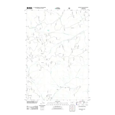
2011 Map of Russian Flat
USGS Topo · Published 2011About this map
The South Fork Judith River carves through this part of Judith Basin County, where the high-altitude landscape is defined by broad openings and mineral prospects. The southern portion of the sheet reveals a concentrated area of historic extraction near Basin Creek, featuring the Jumbo Mine, New Deal Mine, and the Lucky Boy Mine. These workings, along with unnamed sites like the SW NW Section 15 Mine, point to the region's enduring connection to small-scale mountain mining.
Find a feature on this map
34 named features on this map. Tap any name to fly to it.
Don’t see what you’re looking for? This feature index may not catch every label — zoom into the map to look around manually.
Map Details
Editions of this 2011 Russian Flat Map
This is the sole edition of this map. No revisions or reprints were ever made.
Other maps of this area

1886 · Little Belt Mts.
USGS Topo · 1:250,000

1894 · Little Belt Mts.
USGS Topo · 1:250,000

1897 · Little Belt Mts.
USGS Topo · 1:250,000

1898 · Little Belt Mts.
USGS Topo · 1:250,000

1902 · Little Belt Mts.
USGS Topo · 1:250,000

1948 · White Sulphur Springs
USGS Topo · 1:250,000

1958 · White Sulphur Springs
USGS Topo · 1:250,000

1961 · White Sulphur Springs
USGS Topo · 1:250,000
1961 · Sand Point
USGS Topo · 1:24,000
1961 · Neihart
USGS Topo · 1:62,500