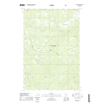
2020 Map of Russian Flat
USGS Topo · Published 2020About this map
Lewis & Clark National Forest encompasses this section of the Little Belt Mountains, where the headwaters of the S Fork Judith River and numerous creeks drain the high country. The landscape is defined by a series of named openings or "parks," including Clyde Park, Willow Park, Bear Park, and High Park, which suggest a history of high-altitude grazing or forestry activities. The Russian Flat Airport stands as a notable clearing in the northern half of the map, situated near the Lower Russian Loop road system. To the south, geological landmarks like Elephant Rock and Mud Ridge rise above the drainages of Whitetail Cr and Basin Creek. This modern survey documents the persistent trails and forest roads, such as Whitetail Logged, that provide access to this isolated mountain terrain near the boundary of Judith Basin and Meagher counties.
Find a feature on this map
41 named features on this map. Tap any name to fly to it.
Don’t see what you’re looking for? This feature index may not catch every label — zoom into the map to look around manually.
Map Details
Editions of this 2020 Russian Flat Map
This is the sole edition of this map. No revisions or reprints were ever made.
Other maps of this area

1886 · Little Belt Mts.
USGS Topo · 1:250,000

1894 · Little Belt Mts.
USGS Topo · 1:250,000

1897 · Little Belt Mts.
USGS Topo · 1:250,000

1898 · Little Belt Mts.
USGS Topo · 1:250,000

1902 · Little Belt Mts.
USGS Topo · 1:250,000

1948 · White Sulphur Springs
USGS Topo · 1:250,000

1958 · White Sulphur Springs
USGS Topo · 1:250,000

1961 · White Sulphur Springs
USGS Topo · 1:250,000
1961 · Sand Point
USGS Topo · 1:24,000
1961 · Neihart
USGS Topo · 1:62,500