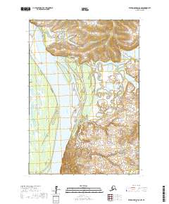
2017 Map of Russian Mission C-8 NW
USGS Topo · Published 2017About this map
Yukon River dominate the western portion of this landscape within the Kusilvak Census Area, carving a wide channel through an intricate network of wetlands and minor tributaries. The river's path is marked by distinctive geographical markers like Round Point, which sits along the eastern bank. To the north and east, the terrain transitions into a complex system of smaller water bodies and seasonal drainages, including Engineer Creek and its namesake Engineer Lake. The presence of Deep Cr in the northern reaches further illustrates the water-dependent nature of this subarctic environment. This 2017 survey by the U.S. Geological Survey utilizes high-resolution data to document the shifting contours of the alluvial plain, offering a precise view of the river's influence on the surrounding topography before the natural cycles of the Alaskan interior further alter the landscape.
Find a feature on this map
9 named features on this map. Tap any name to fly to it.
Don’t see what you’re looking for? This feature index may not catch every label — zoom into the map to look around manually.
Map Details
Editions of this 2017 Russian Mission C-8 NW Map
This is the sole edition of this map. No revisions or reprints were ever made.
Other maps of this area

1947 · Russian Mission
USGS Topo · 1:250,000

1950 · Russian Mission
USGS Topo · 1:250,000

1951 · Marshall
USGS Topo · 1:250,000

1952 · Russian Mission C-8
USGS Topo · 1:63,360
1952 · Russian Mission D-8
USGS Topo · 1:63,360

1952 · Marshall C-1
USGS Topo · 1:63,360
1952 · Marshall D-1
USGS Topo · 1:63,360

1954 · Marshall
USGS Topo · 1:250,000

1980 · Russian Mission
USGS Topo · 1:250,000
2017 · Russian Mission C-8 SW
USGS Topo · 1:25,000