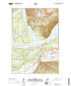
2017 Map of Russian Mission C-8 SW
USGS Topo · Published 2017About this map
Yukon River waters dominate this landscape, carving a complex network of channels and islands through the Kusilvak region of Alaska. The settlement of Ohogamiut sits along the southern bank, positioned where the main river current meets the intricate wetlands and smaller waterways like Washburn Slough. This geography is defined by the shifting nature of the river, which has created distinct landmarks such as the sharp bend at Devils Elbow and the isolated elevations of Cunningham Mtn and Roundabout Mtn.
Find a feature on this map
17 named features on this map. Tap any name to fly to it.
Don’t see what you’re looking for? This feature index may not catch every label — zoom into the map to look around manually.
Map Details
Editions of this 2017 Russian Mission C-8 SW Map
This is the sole edition of this map. No revisions or reprints were ever made.
Other maps of this area

1947 · Russian Mission
USGS Topo · 1:250,000

1950 · Russian Mission
USGS Topo · 1:250,000

1951 · Marshall
USGS Topo · 1:250,000

1952 · Russian Mission C-8
USGS Topo · 1:63,360

1952 · Russian Mission B-8
USGS Topo · 1:63,360

1952 · Marshall C-1
USGS Topo · 1:63,360
1954 · Marshall B-1
USGS Topo · 1:63,360

1954 · Marshall
USGS Topo · 1:250,000

1980 · Russian Mission
USGS Topo · 1:250,000
2017 · Russian Mission B-8 NE
USGS Topo · 1:25,000