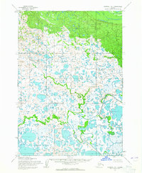
1954 Map of Marshall B-1
USGS Topo · Published 1965About this map
The marshy lowlands of the Seward Meridian dominate this mid-century landscape, characterized by a dense, intricate network of countless unnamed lakes, ponds, and sloughs. Photogrammetric data captured in 1951 reveals the complex hydrology of the Bethel region, where water and tundra intertwine in a pattern typical of the Alaskan interior's river basins. The land is defined by its lack of permanent infrastructure, with no roads, trails, or named settlements appearing across the terrain. Instead, the survey focuses on the raw topography and the pre-calculated boundaries of Range 72 West and Township 15 North, providing a precise record of the unsurveyed and unmarked locations established by the Bureau of Land Management for this remote coastal district.
Find a feature on this map
5 named features on this map. Tap any name to fly to it.
Don’t see what you’re looking for? This feature index may not catch every label — zoom into the map to look around manually.
Map Details
Editions of this 1954 Marshall B-1 Map
2 editions found
Other maps of this area

1947 · Russian Mission
USGS Topo · 1:250,000

1950 · Russian Mission
USGS Topo · 1:250,000

1951 · Marshall
USGS Topo · 1:250,000

1952 · Russian Mission C-8
USGS Topo · 1:63,360

1952 · Russian Mission B-8
USGS Topo · 1:63,360

1952 · Marshall C-1
USGS Topo · 1:63,360

1954 · Russian Mission A-8
USGS Topo · 1:63,360
1954 · Marshall C-2
USGS Topo · 1:63,360

1954 · Marshall A-2
USGS Topo · 1:63,360

1954 · Marshall A-1
USGS Topo · 1:63,360