
1954 Map of Marshall A-2
USGS Topo · Published 1964About this map
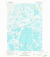
Nunavak Anukslak Lake dominates the central portion of this 1954 topographic study, illustrating the complex hydrology of the Yukon-Kuskokwim Delta region. The landscape is characterized by an intricate network of interconnected tundra ponds, sloughs, and wetlands that define the geography south of the Yukon River. To the west, the map details the northern reaches of Takslesluk Lake, part of a vast aquatic system where land and water blur into a singular, shifting environment. Mapped by the Army Map Service using aerial photography from the early 1950s, the sheet documents a wilderness area before modern development, showing unsurveyed land lines predetermined by the Bureau of Land Management. The absence of roads or permanent settlements at this time reflects the seasonal and water-dependent nature of travel and subsistence in this part of the Alaskan interior.
Find a feature on this map
2 named features on this map. Tap any name to fly to it.
Don’t see what you’re looking for? This feature index may not catch every label — zoom into the map to look around manually.
Map Details
Editions of this 1954 Marshall A-2 Map
2 editions found
Other maps of this area

1951 · Marshall
USGS Topo · 1:250,000

1951 · Baird Inlet
USGS Topo · 1:250,000

1954 · Marshall B-3
USGS Topo · 1:63,360

1954 · Marshall A-3
USGS Topo · 1:63,360

1954 · Marshall A-1
USGS Topo · 1:63,360
1954 · Marshall B-2
USGS Topo · 1:63,360
1954 · Marshall B-1
USGS Topo · 1:63,360

1954 · Marshall
USGS Topo · 1:250,000

1954 · Baird Inlet
USGS Topo · 1:250,000
1954 · Baird Inlet D-1
USGS Topo · 1:63,360