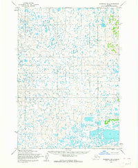
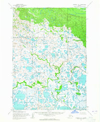
1954 Map of Marshall B-2
USGS Topo · Published 1964About this map
Aerial surveys from the early 1950s revealed an intricate, water-logged landscape within the Seward Meridian, long before modern infrastructure reached this part of the Alaskan interior. This map focuses on the hydrologic complexity of the region, where countless unnamed lakes and ponds fill the drainage basins of Township 14 North through Township 16 North. The topography is defined by subtle elevation changes and a dense network of seasonal water bodies, illustrating the naturally shifting drainage patterns typical of the tundra during this era. Produced through photogrammetric methods by the Army Map Service and edited by the U.S. Geological Survey, the document captures the raw state of the terrain as it existed when the area remained largely unmapped and field checks were limited. The scarcity of named human settlements or trails reflects the isolation of this region at the time of the 1954 annotation, making it a critical reference for understanding the land before subsequent development or environmental shifts.
Find a feature on this map
5 named features on this map. Tap any name to fly to it.
Don’t see what you’re looking for? This feature index may not catch every label — zoom into the map to look around manually.
Map Details
Editions of this 1954 Marshall B-2 Map
3 editions found
Other maps of this area

1951 · Marshall
USGS Topo · 1:250,000

1952 · Marshall C-1
USGS Topo · 1:63,360

1954 · Marshall C-3
USGS Topo · 1:63,360
1954 · Marshall C-2
USGS Topo · 1:63,360

1954 · Marshall B-3
USGS Topo · 1:63,360

1954 · Marshall A-2
USGS Topo · 1:63,360

1954 · Marshall A-3
USGS Topo · 1:63,360

1954 · Marshall A-1
USGS Topo · 1:63,360
1954 · Marshall B-1
USGS Topo · 1:63,360

1954 · Marshall
USGS Topo · 1:250,000