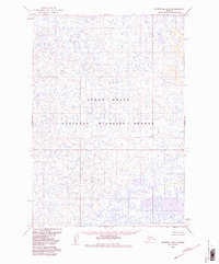
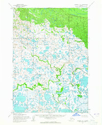
1954 Map of Marshall B-2
USGS Topo · Published 1988About this map
The Yukon Delta National Wildlife Refuge dominates this 1950s survey of the Alaskan interior near Bethel. Mapped primarily through photogrammetric methods using aerial photography from 1951, the landscape is defined by an intricate, fine-grained network of countless small lakes, ponds, and meandering watercourses. This labyrinthine wetland environment reflects the complex hydrology of the delta, where land and water are inextricably linked. The absence of named settlements, roads, or trails during this period highlights the wilderness character of the region, emphasizing a terrain where movement was likely dictated by seasonal water levels and traditional routes not captured by standard topographic conventions of the era. The mapping effort, later updated with federal reservation boundaries from the 1980 Alaska National Interest Lands Conservation Act, serves as a foundation for understanding the preserved natural state of this subarctic ecosystem.
Find a feature on this map
1 named feature on this map. Tap any name to fly to it.
Don’t see what you’re looking for? This feature index may not catch every label — zoom into the map to look around manually.
Map Details
Editions of this 1954 Marshall B-2 Map
3 editions found
Other maps of this area

1951 · Marshall
USGS Topo · 1:250,000

1952 · Marshall C-1
USGS Topo · 1:63,360

1954 · Marshall C-3
USGS Topo · 1:63,360
1954 · Marshall C-2
USGS Topo · 1:63,360

1954 · Marshall B-3
USGS Topo · 1:63,360

1954 · Marshall A-2
USGS Topo · 1:63,360

1954 · Marshall A-3
USGS Topo · 1:63,360

1954 · Marshall A-1
USGS Topo · 1:63,360
1954 · Marshall B-2
USGS Topo · 1:63,360
1954 · Marshall B-1
USGS Topo · 1:63,360