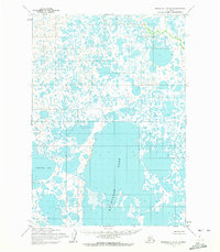
1954 Map of Marshall A-2
USGS Topo · Published 1972About this map
Kayigyalik Lake dominates the southern landscape of this remote subarctic region, representing the intricate water systems characteristic of the Yukon-Kuskokwim Delta. Mapped using photogrammetric methods from 1950s aerial photography, the terrain is defined by a dense labyrinth of thousands of small unnamed ponds, sloughs, and marshlands. To the west, the expanse of Takstesluk Lake marks another significant water body in this largely roadless area. This 1954 field-annotated study by the Army Map Service provides a detailed view of the natural hydrology before modern changes, documenting a landscape where water and land are inextricably linked. The map also features land lines predetermined by the Bureau of Land Management, indicating early administrative efforts in this unsurveyed territory.
Find a feature on this map
2 named features on this map. Tap any name to fly to it.
Don’t see what you’re looking for? This feature index may not catch every label — zoom into the map to look around manually.
Map Details
Editions of this 1954 Marshall A-2 Map
2 editions found
Other maps of this area

1951 · Marshall
USGS Topo · 1:250,000

1951 · Baird Inlet
USGS Topo · 1:250,000

1954 · Marshall B-3
USGS Topo · 1:63,360

1954 · Marshall A-2
USGS Topo · 1:63,360

1954 · Marshall A-3
USGS Topo · 1:63,360

1954 · Marshall A-1
USGS Topo · 1:63,360
1954 · Marshall B-2
USGS Topo · 1:63,360
1954 · Marshall B-1
USGS Topo · 1:63,360

1954 · Marshall
USGS Topo · 1:250,000

1954 · Baird Inlet
USGS Topo · 1:250,000