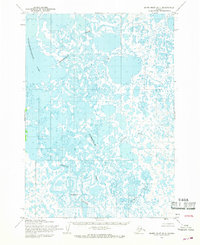
1954 Map of Baird Inlet D-1
USGS Topo · Published 1968About this map
Paingakmeut and Adams appear as isolated settlements within a complex water system in this mid-century Alaskan survey. The landscape is dominated by the intricate distributaries of the Pikmiktalik River and the Kukthluk River, which weave through a dense network of unnamed ponds and marshes. To the northwest, the expansive Nunavakanukakslak Lake defines the terrain, while the Johnson River snakes across the southern portion of the quadrangle.
Find a feature on this map
8 named features on this map. Tap any name to fly to it.
Don’t see what you’re looking for? This feature index may not catch every label — zoom into the map to look around manually.
Map Details
Editions of this 1954 Baird Inlet D-1 Map
2 editions found
Other maps of this area

1947 · Russian Mission
USGS Topo · 1:250,000

1950 · Russian Mission
USGS Topo · 1:250,000

1950 · Bethel
USGS Topo · 1:250,000

1951 · Marshall
USGS Topo · 1:250,000

1951 · Baird Inlet
USGS Topo · 1:250,000

1954 · Russian Mission A-8
USGS Topo · 1:63,360

1954 · Marshall A-2
USGS Topo · 1:63,360

1954 · Marshall A-1
USGS Topo · 1:63,360

1954 · Bethel D-8
USGS Topo · 1:63,360

1954 · Bethel C-8
USGS Topo · 1:63,360