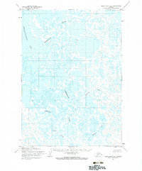
1954 Map of Baird Inlet D-1
USGS Topo · Published 1983About this map
Pikmiktalik River and the sprawling expanse of Nunavakanukakslak Lake dominate this 1950s interior landscape of the Yukon-Kuskokwim Delta. This region, mapped by the Army Map Service using aerial photography, reveals a complex hydrologic network where land and water blur into a labyrinth of tundra ponds and meandering channels. Small settlements and points of interest such as Paingakmeut, Adams, and the aptly named Trouble are documented along these waterways, highlighting the vital role of rivers like the Johnson River and Kukthluk River for transportation and survival. The absence of roads or established trails on the sheet underscores the remote nature of this delta environment during the mid-twentieth century, as mapped by the Geological Survey.
Find a feature on this map
8 named features on this map. Tap any name to fly to it.
Don’t see what you’re looking for? This feature index may not catch every label — zoom into the map to look around manually.
Map Details
Editions of this 1954 Baird Inlet D-1 Map
2 editions found
Other maps of this area

1947 · Russian Mission
USGS Topo · 1:250,000

1950 · Russian Mission
USGS Topo · 1:250,000

1950 · Bethel
USGS Topo · 1:250,000

1951 · Marshall
USGS Topo · 1:250,000

1951 · Baird Inlet
USGS Topo · 1:250,000

1954 · Russian Mission A-8
USGS Topo · 1:63,360

1954 · Marshall A-2
USGS Topo · 1:63,360

1954 · Marshall A-1
USGS Topo · 1:63,360

1954 · Bethel D-8
USGS Topo · 1:63,360

1954 · Bethel C-8
USGS Topo · 1:63,360