
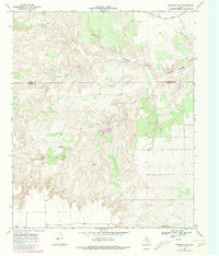
1968 Map of Rustler Camp
USGS Topo · Published 1971About this map
Rustler Camp sits at the heart of this West Texas landscape, positioned just south of the Motley Co Dickens Co line. The terrain is defined by a dense network of watercourses and springs that feed into the Tongue River (South Pease), which cuts across the northern portion of the map. This area represents a classic cattle-and-ranching environment of the late 1960s, where seasonal drainages like Rustler Creek, Grapevine Creek, and Mexican Creek provided vital water sources. In the far northeast corner, the presence of the Quanah Acme and Pacific railroad line suggests the historical importance of rail transport for moving livestock and resources out of the Rolling Plains. Scattered resource extraction points, such as an Oil Well and a Gravel Pit, highlight the industrial activity occurring alongside traditional ranching operations.
Find a feature on this map
16 named features on this map. Tap any name to fly to it.
Don’t see what you’re looking for? This feature index may not catch every label — zoom into the map to look around manually.
Map Details
Editions of this 1968 Rustler Camp Map
2 editions found
Other maps of this area

1954 · Lubbock
USGS Topo · 1:250,000

1965 · Wake
USGS Topo · 1:24,000

1966 · McAdoo
USGS Topo · 1:24,000

1967 · Dickens North
USGS Topo · 1:24,000

1967 · Haystack Mountain
USGS Topo · 1:24,000

1968 · Mac Bain
USGS Topo · 1:24,000

1968 · Roaring Springs
USGS Topo · 1:24,000
1968 · Dougherty
USGS Topo · 1:24,000

1968 · Afton
USGS Topo · 1:24,000

1985 · Dickens
USGS Topo · 1:100,000