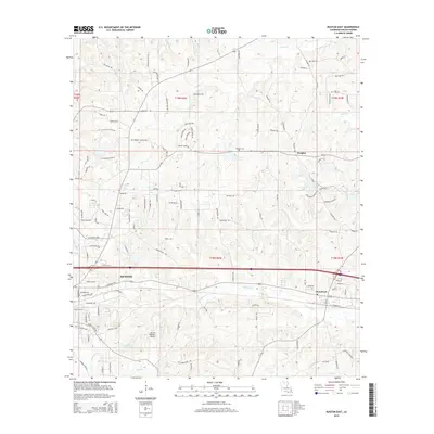
2015 Map of Ruston East
USGS Topo · Published 2015About this map
Ruston anchors the southwestern portion of this Lincoln Parish landscape, revealing the city's eastern expansion toward the village of Choudrant. The terrain is defined by the winding course of Choudrant Cr, which flows through the center of the quadrangle, and the elevated grounds of Pea Ridge to the north. This survey illustrates the modern transportation and infrastructure of North Louisiana, featuring the Ruston Regional Airport and the recreational expanse of Lincoln Parrish Park.
Find a feature on this map
127 named features on this map. Tap any name to fly to it.
Don’t see what you’re looking for? This feature index may not catch every label — zoom into the map to look around manually.
Map Details
Editions of this 2015 Ruston East Map
This is the sole edition of this map. No revisions or reprints were ever made.
Other maps of this area

1950 · Ruston
USGS Topo · 1:62,500

1951 · Ruston
USGS Topo · 1:62,500

1952 · Calhoun
USGS Topo · 1:62,500

1953 · Chatham
USGS Topo · 1:62,500

1953 · Hodge
USGS Topo · 1:62,500

1955 · Shreveport
USGS Topo · 1:250,000

1956 · Shreveport
USGS Topo · 1:250,000
1982 · Downsville North
USGS Topo · 1:24,000
1982 · Eros
USGS Topo · 1:24,000
1982 · Downsville South
USGS Topo · 1:24,000