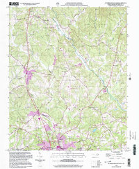
2002 Map of Rutherfordton North
USGS Topo · Published 2003About this map
The Second Broad River and its various tributaries, including Catheys Creek and Big Camp Creek, define the landscape of this Rutherford County region at the start of the 21st century. The map centers on the transition from the upland terrain of Cherry Mountain and Piney Ridge to the developed corridors of the south. The northern reaches maintain a rural character with small crossroads like Union Mills and Gilkey, while the southern portion shows the growing residential and civic density of Rutherfordton, Spindale, and Ruth.
Find a feature on this map
54 named features on this map. Tap any name to fly to it.
Don’t see what you’re looking for? This feature index may not catch every label — zoom into the map to look around manually.
Map Details
Editions of this 2002 Rutherfordton North Map
This is the sole edition of this map. No revisions or reprints were ever made.
Other maps of this area

1900 · Mount Mitchell
USGS Topo · 1:125,000

1902 · Mount Mitchell
USGS Topo · 1:125,000

1905 · Morganton
USGS Topo · 1:125,000

1907 · Saluda
USGS Topo · 1:125,000

1953 · Charlotte
USGS Topo · 1:250,000

1954 · Charlotte
USGS Topo · 1:250,000

1955 · Knoxville
USGS Topo · 1:250,000

1957 · Knoxville
USGS Topo · 1:250,000

1959 · Lake Lure
USGS Topo · 1:62,500

1960 · Knoxville
USGS Topo · 1:250,000