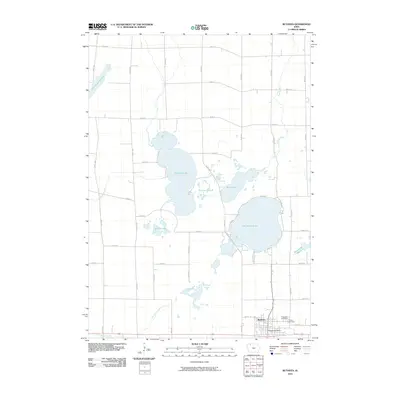
2010 Map of Ruthven
USGS Topo · Published 2010About this map
Lost Island Lake and Trumbull Lake dominate this prairie pothole landscape in northern Iowa, where the town of Ruthven serves as the primary community hub. The map reveals an intricate network of wetlands and water bodies, including the expansive Barringer Slough and Dan Green Slough, which characterize the region's complex hydrology. Within the town of Ruthven, the Ruthven Post Office anchors the small grid of streets, while the local history is preserved at Crown Hill Cemetery and Calvary Cemetery on the eastern edge of the settlement. The surrounding sections are defined by a rigid grid of agricultural roads, such as 300th St and 350th Ave, punctuated by smaller features like Round Lake and the Lost Island Outlet. This survey provides a precise look at the transition from open water to marshlands like Blue Wing Marsh and Smiths Slough.
Find a feature on this map
35 named features on this map. Tap any name to fly to it.
Don’t see what you’re looking for? This feature index may not catch every label — zoom into the map to look around manually.
Map Details
Editions of this 2010 Ruthven Map
This is the sole edition of this map. No revisions or reprints were ever made.
Other maps of this area

1954 · Fairmont
USGS Topo · 1:250,000

1958 · Fairmont
USGS Topo · 1:250,000

1966 · Gillett Grove
USGS Topo · 1:24,000

1966 · Dickens
USGS Topo · 1:24,000

1970 · Spirit Lake SE
USGS Topo · 1:24,000

1972 · Graettinger West
USGS Topo · 1:24,000

1972 · Terril
USGS Topo · 1:24,000

1972 · Wallingford
USGS Topo · 1:24,000

1972 · Ayrshire
USGS Topo · 1:24,000
1972 · Silver Lake
USGS Topo · 1:24,000