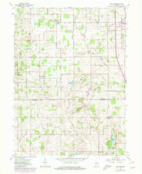
1962 Map of Rutland
USGS Topo · Published 1980About this map
The border of Marshall and Fulton Counties forms the backbone of this northern Indiana landscape, where small rural communities like Rutland and Richland Center anchor a patchwork of agricultural townships. The terrain is marked by an extensive network of drainage infrastructure, including the B F Overmyer Ditch and Eddy Ditch, which were essential for managing the moist lowlands surrounding water bodies like Eddy Lake, Zink Lake, and Anderson Lake.
Find a feature on this map
28 named features on this map. Tap any name to fly to it.
Don’t see what you’re looking for? This feature index may not catch every label — zoom into the map to look around manually.
Map Details
Editions of this 1962 Rutland Map
2 editions found
Other maps of this area

1953 · Chicago
USGS Topo · 1:250,000

1957 · Chicago
USGS Topo · 1:250,000

1957 · Inwood
USGS Topo · 1:24,000

1957 · Plymouth
USGS Topo · 1:24,000

1958 · Donaldson
USGS Topo · 1:24,000

1962 · Pershing
USGS Topo · 1:24,000

1962 · Kewanna
USGS Topo · 1:24,000

1962 · Argos
USGS Topo · 1:24,000
1962 · Rochester
USGS Topo · 1:24,000

1962 · Culver
USGS Topo · 1:24,000