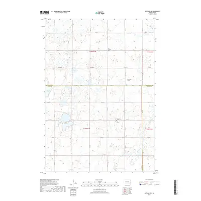
2017 Map of Rutland NW
USGS Topo · Published 2017About this map
Coteau des Prairies, the vast upland plateau, dominates the terrain of this region where Brookings, Lake, and Moody counties meet. The landscape is defined by the glacial hydrology of the prairie pothole region, characterized by features like Pederson Slough, Molumby Slough, and the Mud Lakes. These seasonal and permanent wetlands influenced the placement of the section-line road grid, including Lakeshore Dr and numerous numbered avenues. The map reveals the locations of several rural burial grounds, such as Oslo Lutheran Cem and Prairie Queen Cem, which serve as physical markers of the area's early Scandinavian and pioneer settlement patterns. Along the southern portion of the sheet, the drainage of Battle Creek cuts through the prairie, providing a contrast to the flatter marshlands found further north.
Find a feature on this map
43 named features on this map. Tap any name to fly to it.
Don’t see what you’re looking for? This feature index may not catch every label — zoom into the map to look around manually.
Map Details
Editions of this 2017 Rutland NW Map
This is the sole edition of this map. No revisions or reprints were ever made.
Other maps of this area

1953 · Watertown
USGS Topo · 1:250,000

1958 · Watertown
USGS Topo · 1:250,000

1964 · Brookings
USGS Topo · 1:24,000

1964 · Medary
USGS Topo · 1:24,000

1964 · Rutland SE
USGS Topo · 1:24,000

1968 · Lake Sinai
USGS Topo · 1:24,000

1968 · Volga
USGS Topo · 1:24,000

1968 · Madison
USGS Topo · 1:24,000

1968 · Sinai
USGS Topo · 1:24,000
1968 · Rutland
USGS Topo · 1:24,000
Featured Places
- Camridge Hutterite Colony, SD
- Oslo Township, SD
- Medary Township, SD
- Summit Township, SD
- Fremont Township, SD