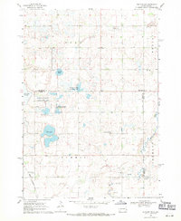
1968 Map of Rutland NW
USGS Topo · Published 1971About this map
Glacial depressions and water management define this landscape on the border of Lake and Brookings Counties. Broad water bodies like Mud Lake and the Pederson Slough dominate the central terrain, much of which is designated as a National Wildlife Management Area. The map reveals a rural community anchored by spiritual and civic landmarks, including the Oslo Ch and Lake Campbell Ch, alongside the Townhall at a central section junction. The southern portion of the sheet is marked by the path of Battle Creek and the steel of the Great Northern railroad, which cuts through the southwest corner near the Prairie Queen Cem. This survey illustrates the late-1960s agricultural character of eastern South Dakota, where sections are clearly delineated by field lines and punctuated by several Gravel Pits supporting local infrastructure.
Find a feature on this map
20 named features on this map. Tap any name to fly to it.
Don’t see what you’re looking for? This feature index may not catch every label — zoom into the map to look around manually.
Map Details
Editions of this 1968 Rutland NW Map
2 editions found
Other maps of this area

1953 · Watertown
USGS Topo · 1:250,000

1958 · Watertown
USGS Topo · 1:250,000

1964 · Brookings
USGS Topo · 1:24,000

1964 · Medary
USGS Topo · 1:24,000

1964 · Rutland SE
USGS Topo · 1:24,000

1968 · Lake Sinai
USGS Topo · 1:24,000

1968 · Volga
USGS Topo · 1:24,000

1968 · Madison
USGS Topo · 1:24,000

1968 · Sinai
USGS Topo · 1:24,000
1968 · Rutland
USGS Topo · 1:24,000
Featured Places
- Fremont Township, SD
- Camridge Hutterite Colony, SD
- Oslo Township, SD
- Summit Township, SD
- Medary Township, SD