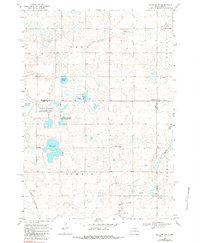
1968 Map of Rutland NW
USGS Topo · Published 1984About this map
The intersections of Brookings, Lake, and Moody counties define this rural landscape during the late 1960s, characterized by a complex network of glacial wetlands and water bodies. Significant marshy features like Pederson Slough and Molumby Slough dominate the northern terrain, while Mud Lake serves as a central landmark within the National Wildlife Management Area. The map documents the distributed social fabric of the townships of Oslo, Medary, Summit, and Fremont, where community life is anchored by several rural institutions.
Find a feature on this map
20 named features on this map. Tap any name to fly to it.
Don’t see what you’re looking for? This feature index may not catch every label — zoom into the map to look around manually.
Map Details
Editions of this 1968 Rutland NW Map
2 editions found
Other maps of this area

1953 · Watertown
USGS Topo · 1:250,000

1958 · Watertown
USGS Topo · 1:250,000

1964 · Brookings
USGS Topo · 1:24,000

1964 · Medary
USGS Topo · 1:24,000

1964 · Rutland SE
USGS Topo · 1:24,000

1968 · Lake Sinai
USGS Topo · 1:24,000

1968 · Volga
USGS Topo · 1:24,000

1968 · Madison
USGS Topo · 1:24,000

1968 · Sinai
USGS Topo · 1:24,000
1968 · Rutland
USGS Topo · 1:24,000
Featured Places
- Fremont Township, SD
- Camridge Hutterite Colony, SD
- Oslo Township, SD
- Summit Township, SD
- Medary Township, SD