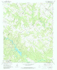
1971 Map of Rutledge North
USGS Topo · Published 1987About this map
Hard Labor Creek State Park dominates the southern landscape of this Walton and Morgan County region, centered around the expansive waters of Lake Rutledge. The area reflects a rural Georgia community structured around small settlements and an extensive network of country churches, such as Chestnut Grove Ch, Gresham Grove Ch, and Prospect Ch. The northern portion is defined by the town of Bostwick, while the community of Rutledge sits at the southwestern edge, near the park's entrance. The drainage patterns of Big Sandy Creek and Turkey Creek dictate the local topography, carving through a landscape primarily devoted to recreation and agriculture. Within the state park boundaries, specialized facilities like Camp Daniel Morgan and Camp Rutledge indicate the era's focus on organized group camping and conservation, preserving a significant portion of the Hard Labor Creek watershed.
Find a feature on this map
37 named features on this map. Tap any name to fly to it.
Don’t see what you’re looking for? This feature index may not catch every label — zoom into the map to look around manually.
Map Details
Editions of this 1971 Rutledge North Map
2 editions found
Other maps of this area

1896 · Monroe
USGS Topo · 1:125,000

1953 · Athens
USGS Topo · 1:250,000

1958 · Athens
USGS Topo · 1:250,000

1959 · Athens
USGS Topo · 1:250,000

1963 · Athens
USGS Topo · 1:250,000

1964 · High Shoals
USGS Topo · 1:24,000

1964 · Watkinsville
USGS Topo · 1:24,000

1964 · Monroe
USGS Topo · 1:24,000

1971 · Rutledge North
USGS Topo · 1:24,000
1971 · Social Circle
USGS Topo · 1:24,000