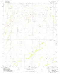
1974 Map of Ryan Draw
USGS Topo · Published 1977About this map
The Graham Co Cochise Co boundary line bisects this arid landscape, where water management is the primary human imprint on the terrain. In the mid-1970s, the region relied on a network of infrastructure to capture infrequent desert rainfall, including the Ryan Detention Dam, Sands Draw Detention Dam, and cattle-related water sources like Charco Tank and Antelope Well. The map captures the transition from the upland drainage of Ryan Draw and Gold Gulch down to the broad alluvial deposit known as The Fan near the San Simon River. Small-scale resource extraction is evident from numerous Mine and Prospect labels scattered across the hills. Outside of the isolated Foote Ranch, the area is largely defined by open range and a sparse network of Jeep Trails.
Find a feature on this map
18 named features on this map. Tap any name to fly to it.
Don’t see what you’re looking for? This feature index may not catch every label — zoom into the map to look around manually.
Map Details
Editions of this 1974 Ryan Draw Map
This is the sole edition of this map. No revisions or reprints were ever made.
Other maps of this area

1917 · San Simon
USGS Topo · 1:125,000

1922 · Willcox
USGS Topo · 1:125,000

1928 · Bowie
USGS Topo · 1:62,500

1944 · Fisher Hills
USGS Topo · 1:62,500

1949 · Bowie
USGS Topo · 1:62,500

1950 · Bowie
USGS Topo · 1:62,500

1954 · Silver City
USGS Topo · 1:250,000

1957 · Luzena
USGS Topo · 1:62,500

1958 · Silver City
USGS Topo · 1:250,000

1962 · Silver City
USGS Topo · 1:250,000