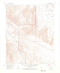
1952 Map of Ryan
USGS Topo · Published 1984About this map
Death Valley National Monument dominates this mid-century topographic study, revealing the stark relief between the Funeral Mountains and the arid depths of Death Valley. The settlement of Ryan and the former Scranton townsite anchor the eastern portion of the map, illustrating the high-altitude mining and transport activity that once defined this region. Significant industrial remnants are visible through the Death Valley Railroad and the Tonopah and Tidewater Railroad, both already marked as dismantled by this era.
Find a feature on this map
27 named features on this map. Tap any name to fly to it.
Don’t see what you’re looking for? This feature index may not catch every label — zoom into the map to look around manually.
Map Details
Editions of this 1952 Ryan Map
5 editions found

Other maps of this area

1908 · Furnace Creek
USGS Topo · 1:250,000

1910 · Furnace Creek
USGS Topo · 1:250,000

1940 · Eagle Tank
USGS Topo · 1:62,500

1942 · Skull Mountain
USGS Topo · 1:125,000

1942 · Bullfrog
USGS Topo · 1:125,000

1948 · Death Valley
USGS Topo · 1:250,000

1951 · Funeral Peak
USGS Topo · 1:62,500

1951 · Eagle Mtn
USGS Topo · 1:62,500

1952 · Chloride Cliff
USGS Topo · 1:50,000

1952 · Ash Meadows
USGS Topo · 1:62,500