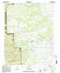
1994 Map of Rye
USGS Topo · Published 1998About this map
Rye and the developing residential grid of Colorado City sit at the transition between the high plains and the peaks of the Sangre de Cristo foothills during the mid-1990s. The landscape is defined by the drainages of Greenhorn Creek and Graneros Creek, which have carved deep paths across the terrain. To the west, the San Isabel National Forest and the Greenhorn Mountain Wilderness preserve the steep slopes of Greenhorn Mountain. This era shows the local infrastructure supporting these communities, including the Fish Hatchery and High School in Rye, while the Brookside Cemetery and the Old San Isabel Road provide links to the area's established history. The presence of several Gravel Pits along the creek beds suggests ongoing local industry and road construction during this period of growth.
Find a feature on this map
30 named features on this map. Tap any name to fly to it.
Don’t see what you’re looking for? This feature index may not catch every label — zoom into the map to look around manually.
Map Details
Editions of this 1994 Rye Map
2 editions found
Other maps of this area

1889 · Canon City
USGS Topo · 1:125,000

1889 · Huerfano Park
USGS Topo · 1:125,000

1891 · Walsenburg
USGS Topo · 1:125,000

1891 · Pueblo
USGS Topo · 1:125,000

1892 · Huerfano Park
USGS Topo · 1:125,000

1892 · Canon City
USGS Topo · 1:125,000

1894 · Walsenburg
USGS Topo · 1:125,000

1894 · Pueblo
USGS Topo · 1:125,000

1896 · Pueblo
USGS Topo · 1:125,000

1897 · Pueblo
USGS Topo · 1:125,000