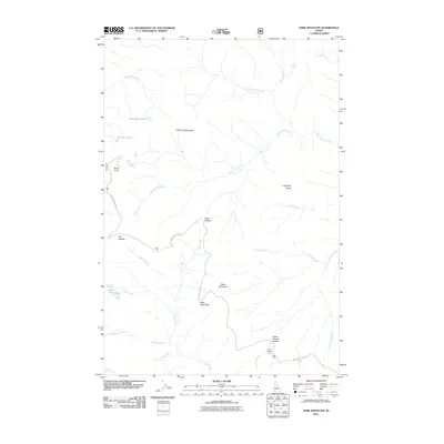
2011 Map of Sabe Mountain
USGS Topo · Published 2011About this map
Nez Perce Trail Rd winds across the high Idaho terrain, following a corridor of significant historical passage through the Clearwater National Forest. This 2011 survey by the U.S. Geological Survey and U.S. Forest Service documents a landscape defined by prominent peaks and mountain saddles, including Sabe Mountain, White Top Mountain, and the notable Sabe Vista Point. The high-elevation hydrology is characterized by several alpine bodies such as Macarthur Lake, Stillman Lake, and Upper Trilby Lake, which feed a complex network of drainages like the Little Clearwater River and Burnt Knob Creek. Cultural markers are sparse but significant, most notably the Horse Heaven Cabin located near Horse Heaven Saddle, providing a waypoint for those navigating the ridge-lines and remote basins of Idaho County.
Find a feature on this map
28 named features on this map. Tap any name to fly to it.
Don’t see what you’re looking for? This feature index may not catch every label — zoom into the map to look around manually.
Map Details
Editions of this 2011 Sabe Mountain Map
This is the sole edition of this map. No revisions or reprints were ever made.
Other maps of this area

1956 · Elk City
USGS Topo · 1:250,000

1960 · Elk City
USGS Topo · 1:250,000

1966 · Spot Mountain
USGS Topo · 1:24,000

1966 · Green Mtn.
USGS Topo · 1:24,000

1966 · Three Prong Mountain
USGS Topo · 1:24,000

1978 · Spread Creek Point
USGS Topo · 1:24,000

1978 · Dennis Mtn
USGS Topo · 1:24,000

1978 · Magruder Mtn
USGS Topo · 1:24,000

1978 · Sheep Hill
USGS Topo · 1:24,000
1979 · Sabe Mtn
USGS Topo · 1:24,000