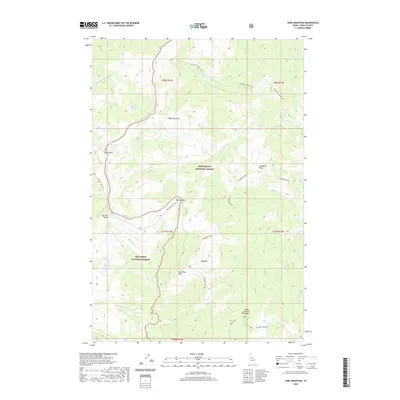
2020 Map of Sabe Mountain
USGS Topo · Published 2020About this map
The Nez Perce Indian Trail traverses this high-elevation Idaho landscape, marking an enduring path through the borderlands of the Bitterroot National Forest and Nez Perce National Forest. The geography is defined by a series of high saddles and mountain peaks, including Sabe Mtn and White Top Mtn, which serve as the headwaters for numerous drainage systems. Waters flow from glacial features like Burnt Knob Lakes, Middle Trilby Lake, and Macarthur Lake into a complex network of creeks such as Sabe Creek and the Little Clearwater River. The presence of the Nez Perce Trail Rd following the historic ridgeline route highlights the continued significance of this ancient corridor. From the prominent Sabe Vista Point, the map reveals a vast wilderness where elevation and water dictate the movement of both historic travelers and modern forest management.
Find a feature on this map
39 named features on this map. Tap any name to fly to it.
Don’t see what you’re looking for? This feature index may not catch every label — zoom into the map to look around manually.
Map Details
Editions of this 2020 Sabe Mountain Map
This is the sole edition of this map. No revisions or reprints were ever made.
Other maps of this area

1956 · Elk City
USGS Topo · 1:250,000

1960 · Elk City
USGS Topo · 1:250,000

1966 · Spot Mountain
USGS Topo · 1:24,000

1966 · Green Mtn.
USGS Topo · 1:24,000

1966 · Three Prong Mountain
USGS Topo · 1:24,000

1978 · Spread Creek Point
USGS Topo · 1:24,000

1978 · Dennis Mtn
USGS Topo · 1:24,000

1978 · Magruder Mtn
USGS Topo · 1:24,000

1978 · Sheep Hill
USGS Topo · 1:24,000
1979 · Sabe Mtn
USGS Topo · 1:24,000