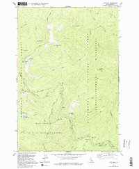
1991 Map of Sabe Mountain
USGS Topo · Published 1995About this map
Sabe Mountain and the surrounding Idaho high country are defined by a network of historic trails and wilderness boundaries established before the mid-1990s. The map captures the meeting of three major protected areas: the Nez Perce National Forest, the Bitterroot National Forest, and the Frank Church-River of No Return Wilderness. This landscape is primarily accessible via the Nez Perce Trail and various pack trails, which navigate between prominent ridges and summits like White Top Mtn and Burnt Knob.
Find a feature on this map
30 named features on this map. Tap any name to fly to it.
Don’t see what you’re looking for? This feature index may not catch every label — zoom into the map to look around manually.
Map Details
Editions of this 1991 Sabe Mountain Map
This is the sole edition of this map. No revisions or reprints were ever made.
Other maps of this area

1956 · Elk City
USGS Topo · 1:250,000

1960 · Elk City
USGS Topo · 1:250,000

1966 · Spot Mountain
USGS Topo · 1:24,000

1966 · Green Mtn.
USGS Topo · 1:24,000

1966 · Three Prong Mountain
USGS Topo · 1:24,000

1978 · Spread Creek Point
USGS Topo · 1:24,000

1978 · Dennis Mtn
USGS Topo · 1:24,000

1978 · Magruder Mtn
USGS Topo · 1:24,000

1978 · Sheep Hill
USGS Topo · 1:24,000
1979 · Sabe Mtn
USGS Topo · 1:24,000