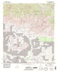
1992 Map of Sabino Canyon
USGS Topo · Published 1995About this map
Coronado National Forest dominates the northern half of this landscape, where high-desert canyons like Ventana Canyon and Sabino Canyon descend toward the growing Tucson outskirts. The 1990s-era residential development in the south is clearly visible, with subdivisions reaching toward the Pusch Ridge Wilderness boundary. Local landmarks such as the Stone House and the Southern Arizona School For Boys sit near the mouth of Bear Creek, illustrating the transition from educational and rural outposts to suburban expansion.
Find a feature on this map
55 named features on this map. Tap any name to fly to it.
Don’t see what you’re looking for? This feature index may not catch every label — zoom into the map to look around manually.
Map Details
Editions of this 1992 Sabino Canyon Map
2 editions found
Other maps of this area

1904 · Tucson
USGS Topo · 1:125,000

1905 · Tucson
USGS Topo · 1:125,000

1948 · Tucson
USGS Topo · 1:62,500

1956 · Tucson
USGS Topo · 1:250,000

1957 · Tucson East
USGS Topo · 1:24,000

1957 · Bellota Ranch
USGS Topo · 1:62,500

1957 · Tucson
USGS Topo · 1:24,000

1957 · Tucson
USGS Topo · 1:62,500

1957 · Rincon Valley
USGS Topo · 1:62,500

1957 · Sabino Canyon
USGS Topo · 1:24,000