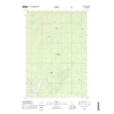
2020 Map of Sable Hill
USGS Topo · Published 2020About this map
Red River Hot Springs serves as the primary landmark in this high-elevation landscape within the Nez Perce National Forest. The area is defined by a dense network of drainages and prominent ridgelines, including Simmons Ridge and Matteson Ridge, which direct the flow of numerous creeks toward the Red River. The southern portion of the map is accessed via Hot Springs Rd, providing a look at the infrastructure surrounding the geothermal site and its proximity to the water system formed by Bridge Cr and Otterson Cr. Notable topographic features such as Sable Hill and the Tamarack Saddle illustrate the complex vertical relief that characterizes the Clearwater Mountains region in Idaho County.
Find a feature on this map
34 named features on this map. Tap any name to fly to it.
Don’t see what you’re looking for? This feature index may not catch every label — zoom into the map to look around manually.
Map Details
Editions of this 2020 Sable Hill Map
This is the sole edition of this map. No revisions or reprints were ever made.
Other maps of this area

1956 · Elk City
USGS Topo · 1:250,000

1960 · Elk City
USGS Topo · 1:250,000

1966 · Green Mtn.
USGS Topo · 1:24,000

1966 · Black Hawk Mtn
USGS Topo · 1:24,000

1966 · Sable Hill
USGS Topo · 1:24,000

1966 · Anderson Butte
USGS Topo · 1:24,000
1966 · Running Lake
USGS Topo · 1:24,000
1966 · Vermilion Peak
USGS Topo · 1:24,000

1977 · Boston Mtn
USGS Topo · 1:24,000

1978 · Spread Creek Point
USGS Topo · 1:24,000