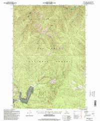
1995 Map of Sable Hill
USGS Topo · Published 1999About this map
Red River Hot Springs serves as a distinct point of human activity within this mountainous corridor of the Nez Perce National Forest. Published in 1999 based on 1963 topography, the map reveals a landscape defined by sharp elevation shifts and drainage systems that converge toward the Red River. The geography is organized by several prominent ridges, including Simmons Ridge and Matteson Ridge, which separate the various creek basins. The presence of multiple administrative zones like the Elk City District and Red River District reflects the complex land management of this remote Idaho backcountry. Localized landmarks such as Sable Hill and Tamarack Saddle provide navigational anchors for researchers tracing the historical trails and forest boundaries that traverse these deep river valleys.
Find a feature on this map
29 named features on this map. Tap any name to fly to it.
Don’t see what you’re looking for? This feature index may not catch every label — zoom into the map to look around manually.
Map Details
Editions of this 1995 Sable Hill Map
This is the sole edition of this map. No revisions or reprints were ever made.
Other maps of this area

1956 · Elk City
USGS Topo · 1:250,000

1960 · Elk City
USGS Topo · 1:250,000

1966 · Green Mtn.
USGS Topo · 1:24,000

1966 · Black Hawk Mtn
USGS Topo · 1:24,000

1966 · Sable Hill
USGS Topo · 1:24,000

1966 · Anderson Butte
USGS Topo · 1:24,000
1966 · Running Lake
USGS Topo · 1:24,000
1966 · Vermilion Peak
USGS Topo · 1:24,000

1977 · Boston Mtn
USGS Topo · 1:24,000

1978 · Spread Creek Point
USGS Topo · 1:24,000