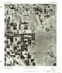
1971 Map of Sacaton Butte
USGS Topo · Published 1972About this map
The community of Casa Blanca and the distinctive geological formation of Sacaton Butte define this orthophotoquad in Pinal County. Taken in the early 1970s, the aerial imagery reveals a sharp contrast between the geometric grid of irrigated agricultural fields and the complex drainage patterns of the uncultivated desert terrain. This orthophotomosaic, prepared by the Geological Survey from 1971 photography, provides a literal overhead perspective of land use in the Gila River Indian Reservation area. The imagery captures the exact footprint of early 1970s desert farming practices, showing the clear boundaries between developed croplands and the natural alluvial fans that characterize this part of the Arizona landscape.
Find a feature on this map
2 named features on this map. Tap any name to fly to it.
Don’t see what you’re looking for? This feature index may not catch every label — zoom into the map to look around manually.
Map Details
Editions of this 1971 Sacaton Butte Map
This is the sole edition of this map. No revisions or reprints were ever made.
Other maps of this area

1913 · Maricopa
USGS Topo · 1:62,500

1914 · Gila Butte
USGS Topo · 1:62,500

1915 · Maricopa
USGS Topo · 1:62,500

1917 · Gila Butte
USGS Topo · 1:62,500

1922 · Casa Grande
USGS Topo · 1:62,500

1924 · Casa Grande
USGS Topo · 1:62,500

1946 · Antelope Peak
USGS Topo · 1:62,500

1948 · Antelope Peak
USGS Topo · 1:62,500

1952 · Gila Butte SE
USGS Topo · 1:24,000

1952 · Maricopa
USGS Topo · 1:24,000