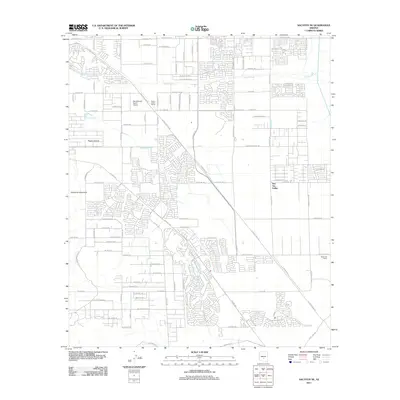
2011 Map of Sacaton NE
USGS Topo · Published 2011About this map
San Tan Valley and the surrounding desert landscape are captured during a period of significant residential expansion in this 2011 survey. The suburban development pattern is clearly visible, with dense street grids such as E Sandwich Dr and W Lenora Way carved into the arid terrain north of the prominent Goldmine Mountain. The area's aviation and agricultural character remains central to its identity, anchored by the Ray Schnepf Ranch Airport and the nearby Pegasus Airpark. These facilities, along with the Queen Creek Siding and Bellavista Farms, suggest a transition from rural ranching to a modern residential hub. The seasonal course of Queen Creek traverses the northern section of the map, while traditional land use is reflected in names like E Horse Mesa Trl and E Hash Knife Draw Rd.
Find a feature on this map
63 named features on this map. Tap any name to fly to it.
Don’t see what you’re looking for? This feature index may not catch every label — zoom into the map to look around manually.
Map Details
Editions of this 2011 Sacaton NE Map
This is the sole edition of this map. No revisions or reprints were ever made.
Other maps of this area

1900 · Florence
USGS Topo · 1:125,000

1902 · Florence
USGS Topo · 1:125,000

1904 · Desert Well
USGS Topo · 1:62,500

1906 · Desert Well
USGS Topo · 1:62,500

1907 · Sacaton
USGS Topo · 1:62,500

1954 · Mesa
USGS Topo · 1:250,000

1956 · Sacaton NE
USGS Topo · 1:24,000

1956 · Magma
USGS Topo · 1:24,000
1956 · Chandler Heights
USGS Topo · 1:24,000

1956 · Desert Well
USGS Topo · 1:24,000