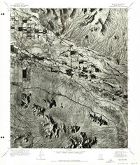
1971 Map of Sacaton
USGS Topo · Published 1972About this map
Santan Mountains rise in the north while the Sacaton Mountains and Sacaton Pk anchor the southern landscape of this 1971 orthophotomosaic. The settlement of Sacaton serves as a central hub, surrounded by a complex network of agricultural plots and irrigation patterns typical of the region. Bisecting the desert terrain, the Gila River flows across the sheet, its riparian corridor contrasting sharply with the arid mountain slopes and the structured grid of cultivated fields. This photographic survey provides an unfiltered look at the mid-century land use and the relationship between the river and the growing community of Sacaton before further modern development.
Find a feature on this map
5 named features on this map. Tap any name to fly to it.
Don’t see what you’re looking for? This feature index may not catch every label — zoom into the map to look around manually.
Map Details
Editions of this 1971 Sacaton Map
This is the sole edition of this map. No revisions or reprints were ever made.
Other maps of this area

1907 · Sacaton
USGS Topo · 1:62,500

1914 · Gila Butte
USGS Topo · 1:62,500

1917 · Gila Butte
USGS Topo · 1:62,500

1922 · Casa Grande
USGS Topo · 1:62,500

1922 · Signal Peak
USGS Topo · 1:62,500

1924 · Signal Peak
USGS Topo · 1:62,500

1924 · Casa Grande
USGS Topo · 1:62,500

1952 · Gila Butte SE
USGS Topo · 1:24,000

1952 · Gila Butte
USGS Topo · 1:24,000

1952 · Gila Butte
USGS Topo · 1:62,500