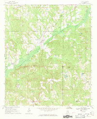
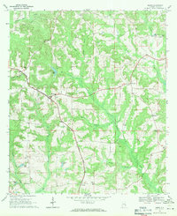
1968 Map of Saco
USGS Topo · Published 1971About this map
The Central of Georgia railroad cuts a diagonal path across this landscape on the border of Pike and Bullock Counties, following the low ground near the Conecuh River. Small rural settlements like Saco, Omega, and Linwood are defined by their proximity to this rail line and the surrounding web of creeks, including Buck Creek and Flat Creek. The area is notably dense with community landmarks, featuring numerous country churches such as Pine Grove Ch, Zebulon Ch, and Macedonia Ch. To the south, Backbone ridge rises above the river valley, while several water bodies like Thad Greens Lake and Green Acres Lake dot the eastern terrain. This 1960s-era geography captures a traditional Alabama agricultural landscape before modern consolidation, where local life centered around rural crossroads like Beans Crossroads and Sandfield.
Find a feature on this map
42 named features on this map. Tap any name to fly to it.
Don’t see what you’re looking for? This feature index may not catch every label — zoom into the map to look around manually.
Map Details
Editions of this 1968 Saco Map
2 editions found
Other maps of this area

1953 · Dothan
USGS Topo · 1:250,000

1954 · Dothan
USGS Topo · 1:250,000

1955 · Dothan
USGS Topo · 1:250,000

1955 · Phenix City
USGS Topo · 1:250,000

1957 · Phenix City
USGS Topo · 1:250,000

1958 · Phenix City
USGS Topo · 1:250,000

1968 · Perote
USGS Topo · 1:24,000
1968 · Josie
USGS Topo · 1:24,000
1968 · Troy
USGS Topo · 1:24,000
1968 · Banks
USGS Topo · 1:24,000