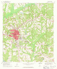
1968 Map of Troy
USGS Topo · Published 1971About this map
The Conecuh River and its numerous tributaries, including Nappy Head Branch and Walnut Creek, carve through the rolling Pike County landscape. At the center of this 1960s-era survey, Troy emerges as a significant regional hub, defined by the expanding campus of Troy State Univ and a dense network of residential streets such as Murphree St and Madison St. The town's industrial and civic footprint is marked by the presence of Edge Memorial Hospital, Memorial Stadium, and the County Fairground, while the rail corridor of the Seaboard Coast Line and Central of Georgia intersect the southern reaches of the settlement.
Find a feature on this map
76 named features on this map. Tap any name to fly to it.
Don’t see what you’re looking for? This feature index may not catch every label — zoom into the map to look around manually.
Map Details
Editions of this 1968 Troy Map
2 editions found
Other maps of this area

1948 · Brundidge
USGS Topo · 1:62,500

1950 · Brundidge
USGS Topo · 1:62,500

1953 · Andalusia
USGS Topo · 1:250,000

1953 · Dothan
USGS Topo · 1:250,000

1954 · Dothan
USGS Topo · 1:250,000

1955 · Dothan
USGS Topo · 1:250,000

1957 · Andalusia
USGS Topo · 1:250,000

1960 · Brundidge
USGS Topo · 1:24,000

1960 · Brundidge NW
USGS Topo · 1:24,000

1962 · Brundidge
USGS Topo · 1:25,000
Featured Places
- Troy, AL
- Edgewood Mobile Home Park, AL
- Antioch, AL
- Mountainbrook, Troy
- Sunset Mountain Mobile Home Park, Troy