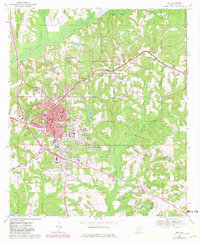
1968 Map of Troy
USGS Topo · Published 1981About this map
Troy serves as the focal point of this Pike County survey, centered around its civic core and the growing campus of Troy State Univ. The town's grid is established by prominent routes like Orion St and Walnut St, with local landmarks such as the Courthouse, City Hall, and Academy St High Sch anchoring the community. Beyond the city center, the landscape is defined by the winding Conecuh River and several family-named landmarks, including McClure Town and Corcoran.
Find a feature on this map
80 named features on this map. Tap any name to fly to it.
Don’t see what you’re looking for? This feature index may not catch every label — zoom into the map to look around manually.
Map Details
Editions of this 1968 Troy Map
2 editions found
Other maps of this area

1948 · Brundidge
USGS Topo · 1:62,500

1950 · Brundidge
USGS Topo · 1:62,500

1953 · Andalusia
USGS Topo · 1:250,000

1953 · Dothan
USGS Topo · 1:250,000

1954 · Dothan
USGS Topo · 1:250,000

1955 · Dothan
USGS Topo · 1:250,000

1957 · Andalusia
USGS Topo · 1:250,000

1960 · Brundidge
USGS Topo · 1:24,000

1960 · Brundidge NW
USGS Topo · 1:24,000

1962 · Brundidge
USGS Topo · 1:25,000
Featured Places
- Troy, AL
- Edgewood Mobile Home Park, AL
- Antioch, AL
- Mountainbrook, Troy
- Sunset Mountain Mobile Home Park, Troy