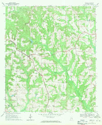
1968 Map of Banks
USGS Topo · Published 1971About this map
The Seaboard Coast Line railroad bisects this Pike County landscape, serving as a primary corridor through the settlements of Banks and Pronto. During the late 1960s, this area remained largely agricultural and rural, defined by a network of family-named water bodies and community anchors. Local history is deeply rooted in the numerous country churches and cemeteries scattered across the terrain, including Westminster Ch, Ramah Ch, and Antioch Ch. Educational and spiritual life intersected at sites like Bethel Sch and its neighboring Bethel Ch. Drainage patterns are dictated by Richland Creek and Whitewater Creek, which feed into various ponds such as Pikes Pond and Wilsons Pond, illustrating the localized water management essential to the region's land use during this era.
Find a feature on this map
38 named features on this map. Tap any name to fly to it.
Don’t see what you’re looking for? This feature index may not catch every label — zoom into the map to look around manually.
Map Details
Editions of this 1968 Banks Map
This is the sole edition of this map. No revisions or reprints were ever made.
Other maps of this area

1948 · Brundidge
USGS Topo · 1:62,500

1950 · Brundidge
USGS Topo · 1:62,500

1953 · Dothan
USGS Topo · 1:250,000

1954 · Dothan
USGS Topo · 1:250,000

1955 · Dothan
USGS Topo · 1:250,000

1960 · Brundidge
USGS Topo · 1:24,000

1960 · Brundidge NW
USGS Topo · 1:24,000

1962 · Brundidge
USGS Topo · 1:25,000
1962 · Brundidge NW
USGS Topo · 1:25,000

1968 · Perote
USGS Topo · 1:24,000