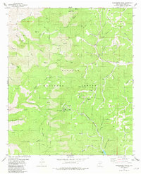
1981 Map of Sacramento Peak
USGS Topo · Published 1982About this map
Sunspot serves as a central scientific landmark within this high-elevation terrain of the Lincoln National Forest. The landscape is dominated by sophisticated technical installations, including the Solar Observatory Telescope Domes and the Cosmic Ray Observatory, established atop Sacramento Peak. These facilities are supported by local infrastructure like a Heliport and dedicated Radio Facility, reflecting the area's importance for astrophysical research in the late twentieth century.
Find a feature on this map
67 named features on this map. Tap any name to fly to it.
Don’t see what you’re looking for? This feature index may not catch every label — zoom into the map to look around manually.
Map Details
Editions of this 1981 Sacramento Peak Map
This is the sole edition of this map. No revisions or reprints were ever made.
Other maps of this area

1950 · Escondido Canyon
USGS Topo · 1:62,500

1950 · Alamogordo
USGS Topo · 1:62,500

1952 · Cloudcroft
USGS Topo · 1:62,500

1954 · Carlsbad
USGS Topo · 1:250,000

1958 · Carlsbad
USGS Topo · 1:250,000

1965 · Rogers Ruins
USGS Topo · 1:24,000
1974 · Bluff Springs
USGS Topo · 1:24,000

1976 · Mule Peak
USGS Topo · 1:24,000
1976 · Alamogordo
USGS Topo · 1:24,000
1977 · Cloudcroft
USGS Topo · 1:24,000