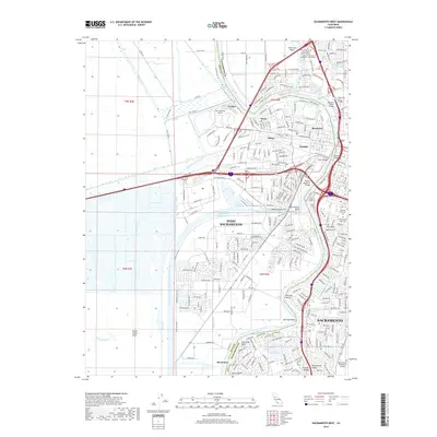
2018 Map of Sacramento West
USGS Topo · Published 2018About this map
West Sacramento and the Sacramento waterfront are defined by an intricate network of waterways and industrial infrastructure in this 2018 survey. The landscape is dominated by the Sacramento River Deep Water Ship Channel, which carves south past Lake Washington and Greens Lake, reflecting the region's importance as a maritime transit hub. Across the Sacramento River, the urban grid of the state capital includes landmarks like the Tower Bridge and Pioneer Memorial Bridge, connecting it to the communities of Broderick, Bryte, and Peethill. This map captures the modern layout of the city's western edge, from the Putah Creek Sinks to the historic burial grounds on the eastern bank, including the City Cem and Masonic Lawn Cem. The survey detail highlights the engineering required to manage this river-valley terrain, from the Toe Drain and Tule Canal to the various bends like Chicory Bend.
Find a feature on this map
54 named features on this map. Tap any name to fly to it.
Don’t see what you’re looking for? This feature index may not catch every label — zoom into the map to look around manually.
Map Details
Editions of this 2018 Sacramento West Map
This is the sole edition of this map. No revisions or reprints were ever made.
Other maps of this area

1891 · Sacramento
USGS Topo · 1:125,000

1892 · Sacramento
USGS Topo · 1:125,000

1893 · Sacramento
USGS Topo · 1:125,000

1894 · Lodi
USGS Topo · 1:125,000

1902 · Fairoaks
USGS Topo · 1:62,500

1907 · Davisville
USGS Topo · 1:62,500

1908 · Courtland
USGS Topo · 1:62,500

1909 · Florin
USGS Topo · 1:31,680

1911 · Brighton
USGS Topo · 1:31,680

1911 · Arcade
USGS Topo · 1:31,680
Featured Places
- Sacramento, CA
- West Sacramento, CA
- Mikon, West Sacramento
- Lovdal, West Sacramento
- Broderick, West Sacramento