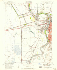
1948 Map of Sacramento West
USGS Topo · Published 1958About this map
The Sacramento River winds through a landscape defined by industrial development and flood control in the years following World War II. On the Yolo County side, the communities of Bryte, Broderick, and West Sacramento show a dense grid of early suburban expansion, supported by institutions like Westacre Sch and a local Drive-in Theater. The infrastructure of the era is evident in the massive Sacramento Bypass and the Yolo Causeway spanning the seasonal floodwaters of the Tule Canal.
Find a feature on this map
60 named features on this map. Tap any name to fly to it.
Don’t see what you’re looking for? This feature index may not catch every label — zoom into the map to look around manually.
Map Details
Editions of this 1948 Sacramento West Map
This is the sole edition of this map. No revisions or reprints were ever made.
Other maps of this area

1891 · Sacramento
USGS Topo · 1:125,000

1892 · Sacramento
USGS Topo · 1:125,000

1893 · Sacramento
USGS Topo · 1:125,000

1894 · Lodi
USGS Topo · 1:125,000

1902 · Fairoaks
USGS Topo · 1:62,500

1907 · Davisville
USGS Topo · 1:62,500

1908 · Courtland
USGS Topo · 1:62,500

1909 · Florin
USGS Topo · 1:31,680

1911 · Brighton
USGS Topo · 1:31,680

1911 · Arcade
USGS Topo · 1:31,680
Featured Places
- Sacramento, CA
- West Sacramento, CA
- Mikon, West Sacramento
- Riverview, West Sacramento
- Lovdal, West Sacramento