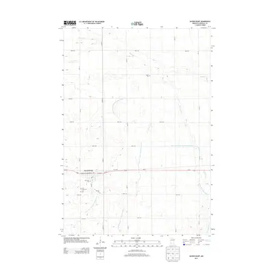
2013 Map of Sacred Heart
USGS Topo · Published 2013About this map
Sacred Heart serves as the primary focal point of this Renville County landscape, situated along the Us-212 corridor. The town is marked by a concentration of local institutions, including the Po and several denominational burial grounds clustered to the south, such as Our Saviors Cem, First English Cem, Trinity Cem, and Ebenezer Cem. This cluster suggests a community with deep roots and various congregational histories. Outside the town limits, the terrain is defined by an extensive network of managed waterways, including Chetomba Cr and Sacred Heart Cr, alongside numerous engineered channels like County Ditch Number One Hundred Sixteen. The geometric grid of rural roads, including 880th Ave and Co Hwy-9, illustrates the organized agricultural partition of the Minnesota prairie during this era.
Find a feature on this map
35 named features on this map. Tap any name to fly to it.
Don’t see what you’re looking for? This feature index may not catch every label — zoom into the map to look around manually.
Map Details
Editions of this 2013 Sacred Heart Map
This is the sole edition of this map. No revisions or reprints were ever made.
Other maps of this area

1952 · Redwood Falls
USGS Topo · 1:62,500

1953 · New Ulm
USGS Topo · 1:250,000

1957 · New Ulm
USGS Topo · 1:250,000

1958 · New Ulm
USGS Topo · 1:250,000

1965 · Lone Tree Lake
USGS Topo · 1:24,000

1965 · Iverson Lake
USGS Topo · 1:24,000
1965 · Maynard
USGS Topo · 1:24,000
1965 · Clara City
USGS Topo · 1:24,000

1965 · Sacred Heart
USGS Topo · 1:24,000

1965 · Renville
USGS Topo · 1:24,000