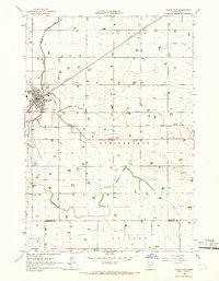
1965 Map of Clara City
USGS Topo · Published 1966About this map
Clara City serves as the primary hub of this west-central Minnesota landscape, situated at the junction of the Great Northern and Chicago and North Western railroads. The town's layout is clearly defined alongside the industrial tracks, with the Bethany Cem and a Sewage Disposal plant located on its outskirts. This mid-1960s survey captures a transition in land management across the Chippewa and Renville county line, characterized by an extensive network of water control features including Judicial Ditch No 3 and Judicial Ditch No 52. These man-made channels support the intensive agriculture across the townships of Lone Tree, Rheiderland, and Ericson. Outside the main settlement, smaller communities like Bunde and Wang appear as localized clusters within the sprawling grid of section lines and field boundaries. The meandering course of Hawk Creek provides a natural contrast to the rigid engineering of the judicial ditches and rail lines that dominate the prairie.
Find a feature on this map
20 named features on this map. Tap any name to fly to it.
Don’t see what you’re looking for? This feature index may not catch every label — zoom into the map to look around manually.
Map Details
Editions of this 1965 Clara City Map
This is the sole edition of this map. No revisions or reprints were ever made.
Other maps of this area

1953 · New Ulm
USGS Topo · 1:250,000

1953 · Saint Cloud
USGS Topo · 1:250,000

1957 · Saint Cloud
USGS Topo · 1:250,000

1957 · New Ulm
USGS Topo · 1:250,000

1958 · New Ulm
USGS Topo · 1:250,000

1958 · Saint Cloud
USGS Topo · 1:250,000

1958 · Kerkhoven SE
USGS Topo · 1:24,000

1958 · Kerkhoven SW
USGS Topo · 1:24,000

1958 · Raymond
USGS Topo · 1:24,000
1965 · Maynard
USGS Topo · 1:24,000