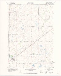
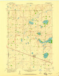
1958 Map of Raymond
USGS Topo · Published 1960About this map
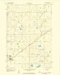
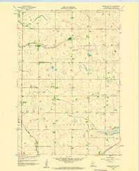
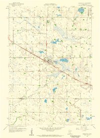
The Great Northern railroad dictates the landscape of this southwestern Kandiyohi County area, cutting a diagonal path that connects the settlements of Raymond and Priam. In the late 1950s, this region was a primary agricultural hub, with the town of Raymond serving as a central point for local commerce and community life. The rural sections are dotted with landmarks of early settlement education and faith, including Golden Grove Sch, School No 809, and the Lutheran Ch. The meandering course of Hawk Creek winds through the townships of St Johns and Edwards, providing a natural contrast to the rigid grid of section lines and the steel rail corridor. Genealogists can find specific burial records at Fairview Cem, while the presence of a Gravel Pit indicates the local industrial activity of the period.
Find a feature on this map
14 named features on this map. Tap any name to fly to it.
Don’t see what you’re looking for? This feature index may not catch every label — zoom into the map to look around manually.
Map Details
Editions of this 1958 Raymond Map
2 editions found
Other maps of this area

1953 · New Ulm
USGS Topo · 1:250,000

1953 · Saint Cloud
USGS Topo · 1:250,000

1957 · Saint Cloud
USGS Topo · 1:250,000

1957 · New Ulm
USGS Topo · 1:250,000

1958 · New Ulm
USGS Topo · 1:250,000

1958 · Saint Cloud
USGS Topo · 1:250,000
1958 · Kerkhoven SE
USGS Topo · 1:24,000
1958 · Kerkhoven
USGS Topo · 1:24,000
1958 · Pennock
USGS Topo · 1:24,000
1958 · Willmar
USGS Topo · 1:24,000