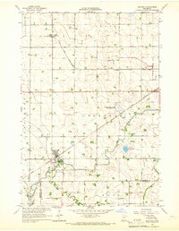
1965 Map of Maynard
USGS Topo · Published 1966About this map
Maynard serves as a central hub for the surrounding agricultural landscape in the mid-1960s, situated at the junction of the Great Northern and Chicago and North Western railroads. The town layout is clearly defined, including its public Park and essential infrastructure like the Sewage Disposal facility. To the north, the small settlement of Gluek (Wesota Sta) sits along the rail line, while the rural township structures of Stoneham, Havelock, and Wang are evident through a network of section lines and drainage systems such as County Ditch No 15. The hydrological character of the region is dominated by Hawk Creek and Chetomba Creek, which meander through the southern reaches. Conservation and land management are visible through the Franko State Wildlife Management Area, while local spiritual life is anchored by Wang Ch in the southern portion of the quadrangle.
Find a feature on this map
24 named features on this map. Tap any name to fly to it.
Don’t see what you’re looking for? This feature index may not catch every label — zoom into the map to look around manually.
Map Details
Editions of this 1965 Maynard Map
This is the sole edition of this map. No revisions or reprints were ever made.
Other maps of this area

1953 · New Ulm
USGS Topo · 1:250,000

1953 · Saint Cloud
USGS Topo · 1:250,000

1957 · Saint Cloud
USGS Topo · 1:250,000

1957 · New Ulm
USGS Topo · 1:250,000

1958 · New Ulm
USGS Topo · 1:250,000

1958 · Saint Cloud
USGS Topo · 1:250,000

1958 · Kerkhoven SE
USGS Topo · 1:24,000

1958 · Kerkhoven SW
USGS Topo · 1:24,000

1958 · Gracelock
USGS Topo · 1:24,000

1965 · Asbury
USGS Topo · 1:24,000