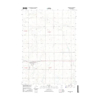
2016 Map of Sacred Heart
USGS Topo · Published 2016About this map
Sacred Heart serves as the primary hub for this portion of Renville County, where the grid of agricultural roads meets a landscape defined by drainage engineering and small-town institutions. The map reveals a high density of rural burial grounds, including Krogfus Cem, Our Saviors Cem, and Ebenezer Cem, which point to the established genealogy of the surrounding farmsteads. Natural watercourses like Chetomba Cr and Spring Cr wind through the northern sections, while the southern terrain is heavily managed by a system of numbered waterways such as County Ditch Number One Hundred Sixteen and County Ditch Number One Hundred Nineteen. This intricate network of ditches reflects the transition of the Minnesota prairie into highly productive farmland. The area remains anchored by local centers of faith, such as First English Cem and Trinity Cem, marking the heritage of the local community.
Find a feature on this map
34 named features on this map. Tap any name to fly to it.
Don’t see what you’re looking for? This feature index may not catch every label — zoom into the map to look around manually.
Map Details
Editions of this 2016 Sacred Heart Map
This is the sole edition of this map. No revisions or reprints were ever made.
Other maps of this area

1952 · Redwood Falls
USGS Topo · 1:62,500

1953 · New Ulm
USGS Topo · 1:250,000

1957 · New Ulm
USGS Topo · 1:250,000

1958 · New Ulm
USGS Topo · 1:250,000

1965 · Lone Tree Lake
USGS Topo · 1:24,000

1965 · Iverson Lake
USGS Topo · 1:24,000
1965 · Maynard
USGS Topo · 1:24,000
1965 · Clara City
USGS Topo · 1:24,000

1965 · Sacred Heart
USGS Topo · 1:24,000

1965 · Renville
USGS Topo · 1:24,000