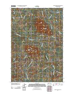
2011 Map of Saddle Mountain
USGS Topo · Published 2011About this map
Saddle Mountain and Humbug Mountain anchor this high-elevation terrain in Clatsop County, where the headwaters of several major Oregon coastal rivers originate. The landscape is defined by its drainage systems, notably the Lewis and Clark River flowing northwest and the Youngs River and its South Fork moving north. In the southern portion of the map, the Necanicum River and the Little North Fork Nehalem River trace significant east-west corridors. Access is facilitated by the Saddle Mountain Rd leading into Saddle Mountain State Park. This topography reveals a complex network of creeks like West Humbug Creek and Beaver Creek, highlighting the importance of timber and watershed management in the Coast Range at the start of the 2010s.
Find a feature on this map
21 named features on this map. Tap any name to fly to it.
Don’t see what you’re looking for? This feature index may not catch every label — zoom into the map to look around manually.
Map Details
Editions of this 2011 Saddle Mountain Map
This is the sole edition of this map. No revisions or reprints were ever made.
Other maps of this area

1919 · Astoria
USGS Topo · 1:62,500

1939 · Astoria
USGS Topo · 1:62,500

1939 · Saddle Mountain
USGS Topo · 1:62,500

1940 · Svensen
USGS Topo · 1:62,500

1940 · Cape Falcon
USGS Topo · 1:62,500

1943 · Saddle Mtn.
USGS Topo · 1:62,500

1948 · Vancouver
USGS Topo · 1:250,000

1949 · Green Mountain
USGS Topo · 1:24,000
1949 · Olney
USGS Topo · 1:24,000

1950 · Vancouver
USGS Topo · 1:250,000