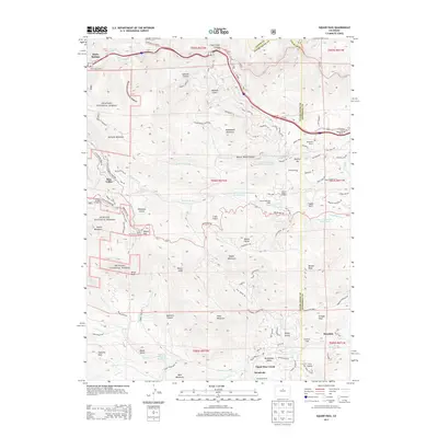
2013 Map of Saddleback Mountain
USGS Topo · Published 2013About this map
Silver Spruce Mill stands at the edge of Idaho Springs in this modern topographic study of the Front Range. The landscape is defined by its transition from the steep corridors of Clear Creek in the north to the high ridges of Arapaho National Forest to the west. This 2013 survey illustrates how legacy land holdings like Beaver Brook Ranch, Elmgreen Ranch, and Brookvale Ranch coexist with recreational infrastructure, including the Pass Picnic Ground near Squaw Pass. Higher elevations are marked by prominent summits such as Saddleback Mountain, Santa Fe Mountain, and Bergen Peak. Residential clusters like Blue Valley and Rosedale appear alongside specialized landmarks such as Squaw Mountain Lodge and Beaver Brook Lodge, reflecting the area's development as a mountain retreat and residential corridor.
Find a feature on this map
114 named features on this map. Tap any name to fly to it.
Don’t see what you’re looking for? This feature index may not catch every label — zoom into the map to look around manually.
Map Details
Editions of this 2013 Saddleback Mountain Map
This is the sole edition of this map. No revisions or reprints were ever made.
Other maps of this area

1899 · West Denver
USGS Topo · 1:125,000

1903 · Georgetown
USGS Topo · 1:62,500

1905 · Central City
USGS Topo · 1:62,500

1905 · Georgetown
USGS Topo · 1:62,500

1906 · Blackhawk
USGS Topo · 1:62,500

1910 · Central City
USGS Topo · 1:62,500

1912 · Central City
USGS Topo · 1:62,500

1942 · Central City
USGS Topo · 1:24,000

1942 · Black Hawk
USGS Topo · 1:24,000

1942 · Ralston Buttes
USGS Topo · 1:24,000