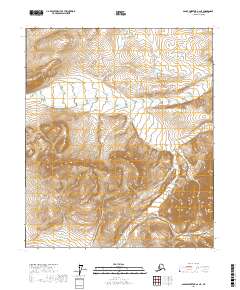
2017 Map of Sagavanirktok A-2 NE
USGS Topo · Published 2017About this map
Gilead Creek defines the east-west drainage corridor in this northern section of the Alaska North Slope, cutting through a high-elevation landscape marked by steep contour intervals and the Public Land Survey System grid. The survey details a remote portion of the Brooks Range foothills, where the seasonal waterway and its smaller tributary Gilead Cr navigate around unnamed summits rising over 3,000 feet. The map is primarily structured by township and range divisions, specifically covering portions of T2S, T3S, and T4S within R18E and R19E. This topographic study emphasizes the pure physical geography of the arctic interior, showing a complete absence of human infrastructure, roads, or permanent settlements at the time of the 2017 data collection. Instead, the focus remains on the complex drainage patterns and the specific elevations of the mountain ridges that separate the various forks of the local creek system.
Find a feature on this map
8 named features on this map. Tap any name to fly to it.
Don’t see what you’re looking for? This feature index may not catch every label — zoom into the map to look around manually.
Map Details
Editions of this 2017 Sagavanirktok A-2 NE Map
This is the sole edition of this map. No revisions or reprints were ever made.
Other maps of this area

1951 · Sagavanirktok D-5
USGS Topo · 1:250,000

1956 · Sagavanirktok
USGS Topo · 1:250,000

1958 · Sagavanirktok
USGS Topo · 1:250,000

1964 · Sagavanirktok
USGS Topo · 1:250,000
1971 · Sagavanirktok A-1
USGS Topo · 1:63,360
1971 · Sagavanirktok B-1
USGS Topo · 1:63,360
1971 · Sagavanirktok A-2
USGS Topo · 1:63,360
1971 · Sagavanirktok B-2
USGS Topo · 1:63,360
2017 · Sagavanirktok A-1 SW
USGS Topo · 1:25,000
2017 · Sagavanirktok A-2 SE
USGS Topo · 1:25,000