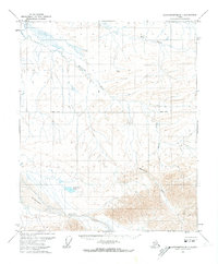
1971 Map of Sagavanirktok B-1
USGS Topo · Published 1973About this map
The Shaviovik River meanders through this portion of the North Slope, revealing a landscape defined by its remote Arctic water systems in the early 1970s. This survey, compiled from 1970 aerial photography, documents the braided channels of the Echooka River and the isolated Cache One Lake before significant industrial infrastructure reached this specific interior quadrangle. A single Drill Hole serves as a lone marker of exploratory activity amidst a terrain primarily characterized by drainages like Kemik Creek and Fin Creek. The mapping reflects a transitional period when the Bureau of Land Management was still predetermining unsurveyed land lines, marking a moment in time when much of the region remained unmarked and wild.
Find a feature on this map
7 named features on this map. Tap any name to fly to it.
Don’t see what you’re looking for? This feature index may not catch every label — zoom into the map to look around manually.
Map Details
Editions of this 1971 Sagavanirktok B-1 Map
This is the sole edition of this map. No revisions or reprints were ever made.
Other maps of this area

1951 · Sagavanirktok D-5
USGS Topo · 1:250,000

1951 · Mt. Michelson
USGS Topo · 1:250,000

1955 · Mount Michelson C-5
USGS Topo · 1:63,360
1955 · Sagavanirktok C-1
USGS Topo · 1:63,360

1956 · Mt. Michelson
USGS Topo · 1:250,000

1956 · Sagavanirktok
USGS Topo · 1:250,000

1958 · Sagavanirktok
USGS Topo · 1:250,000

1964 · Sagavanirktok
USGS Topo · 1:250,000
1971 · Sagavanirktok C-2
USGS Topo · 1:63,360
1971 · Sagavanirktok A-1
USGS Topo · 1:63,360