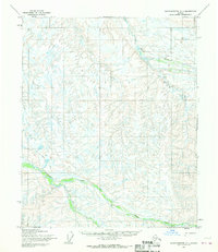
1955 Map of Sagavanirktok C-1
USGS Topo · Published 1970About this map
Kavik River and Juniper Creek define the drainage patterns of this subarctic landscape on Alaska's North Slope as it was documented in the mid-1950s. The terrain is characterized by a dense network of braided streams and small tundra ponds, typical of the permafrost-underlain coastal plain and foothills. Human presence in this environment is sparse, indicated primarily by a seasonal Winter Trail that cuts across the western portion of the sheet. A small cluster of Cabins situated along the banks of Juniper Creek serves as the only named settlement or shelter, likely representing a temporary camp for hunting, trapping, or early resource exploration. This survey, mapped by the Army Map Service, captures the region before the large-scale industrial shifts that would later transform parts of the North Slope.
Find a feature on this map
4 named features on this map. Tap any name to fly to it.
Don’t see what you’re looking for? This feature index may not catch every label — zoom into the map to look around manually.
Map Details
Editions of this 1955 Sagavanirktok C-1 Map
2 editions found
Other maps of this area

1951 · Sagavanirktok D-5
USGS Topo · 1:250,000

1951 · Mt. Michelson
USGS Topo · 1:250,000

1955 · Mount Michelson C-5
USGS Topo · 1:63,360

1955 · Mount Michelson D-5
USGS Topo · 1:63,360
1955 · Sagavanirktok D-2
USGS Topo · 1:63,360
1955 · Sagavanirktok D-1
USGS Topo · 1:63,360

1956 · Mt. Michelson
USGS Topo · 1:250,000

1956 · Sagavanirktok
USGS Topo · 1:250,000

1958 · Sagavanirktok
USGS Topo · 1:250,000

1964 · Sagavanirktok
USGS Topo · 1:250,000